
Everything Alpora can do
An interactive 2D and 3D resort map for your guests and a simple admin for you. An overview for marketing, operations and your web team.
The map for guests
What visitors see on your website and on their phones.
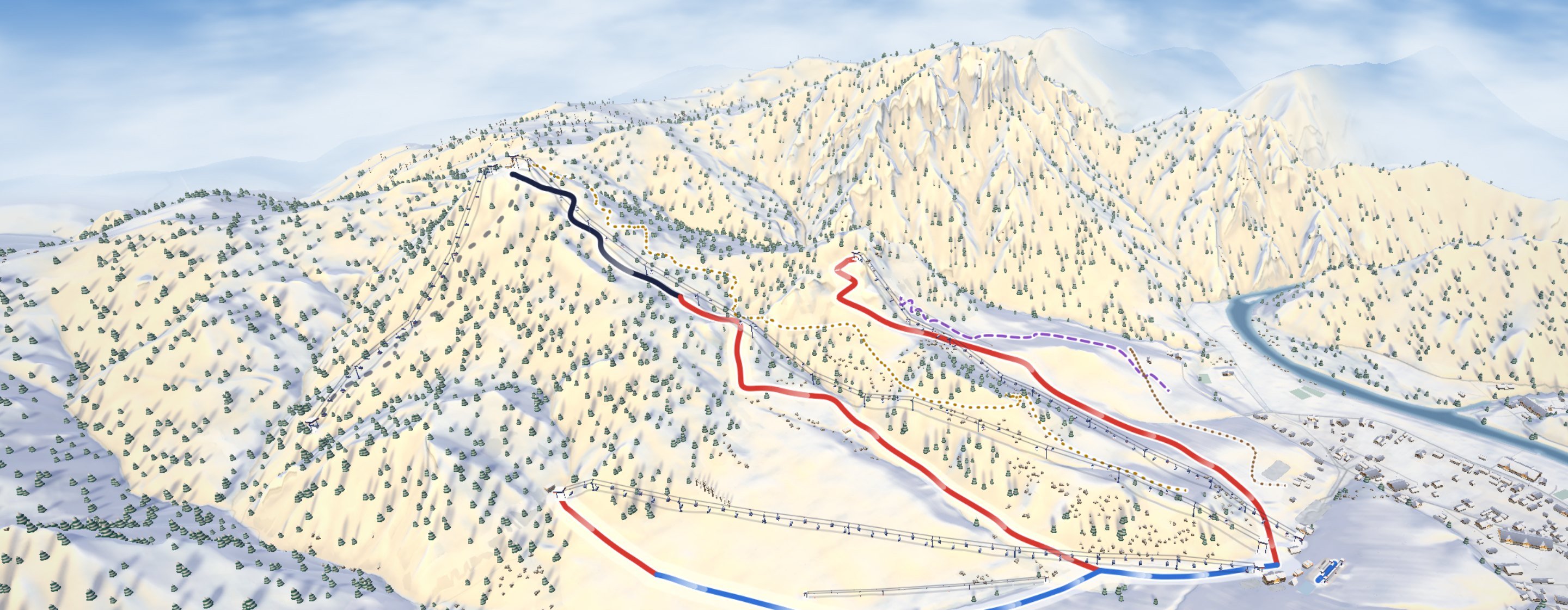
- 3D and 2D
- Terrain from precise elevation data, forests, buildings and lifts where they really stand. 2D is a top-down view. Works with a mouse, fingers and the keyboard.
- Winter and summer on one map
- The season switches by date on its own, and if you like, visitors can switch it themselves. In summer: bike park, hiking trails, cycling routes, summer services and lifts.
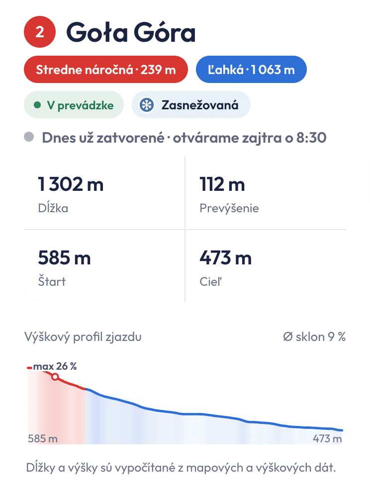
- Runs
- Difficulty by section, length, vertical drop, start and finish, elevation profile with average and maximum gradient. Freeride, snowmaking and night skiing.
- Lifts
- Lift type, station altitudes and the cable profile above the terrain. Capacity and ride time if you enter them. Bike transport in summer.
- Trails
- Cross-country, ski touring, sledging, winter walking, hiking with waymark colour and cycling routes – length, ascent, descent and profile.
- Live status
- Open or closed, “open until…” and the time of the last change. The map refreshes on its own.
- Opening hours
- For the resort, lifts and services. “Open now” based on the time at the resort.
- Services and buildings
- Restaurants, rentals, ticket offices, toilets, first aid, car parks with price and access, and more. Services in one building share one label, with photos and a filter by category.
- Weather
- Temperature at the bottom and the top, and wind. When it snows at the resort, it snows on the map.
- Search and filter
- Search works without diacritics. Filter by difficulty, open only and by map layer.
- Notice on the map
- A short message for guests, valid until a date you choose.
- Five languages
- Slovak, Czech, Polish, English and German.
- Like an app on phones
- Bottom panel, add to home screen and the last status without signal.
Admin for the resort
What you do – on your phone or computer.
 Alpora
Resort status
Last change 7:43
- Lúka
Closed · 1,062 m · ↘ 74 m · Floodlit · Night skiing
- Zajko
Open · 62 m · ↘ 1 m · Floodlit · Night skiing
- Goła Góra
Open · 1,302 m · ↘ 112 m · Snowmaking
- Podskalnia
Open · 1,327 m · ↘ 228 m · Floodlit · Snowmaking · Night skiing
- Nowa Góra
Open · 1,891 m · ↘ 411 m · Snowmaking
- Žľab pod Nowou
Closed · 648 m · ↘ 237 m
Try it – the switches work
- Resort status
- A switch for every run and lift, or “Open / Close all” at once. Snowmaking, night operation and a note.
- Hours
- Day, night skiing and summer operation. Named schedules for lifts and services.
- Services and buildings
- Add a service, move it on the map, set its type, hours and photo, reorder by dragging or hide it. Rename a building, add a photo, choose its look on the map and draw one that is missing.
- Runs and trails
- Name, number, difficulty, official figures, order and hiding. A run editor on the map – split, join, change a section's difficulty – and drawing a new trail.
- Seasons
- Which lifts and services run in winter and which in summer.
- Map settings
- Opening view and lighting, effects – skiers, cars in car parks, snowfall –, languages, weather, notice, logo and app icon.
- Names on the map
- Rename or hide peaks, villages and water.
- Change history
- Who changed what and when.
- Visitors
- How many guests opened the map, where they came from, what interests them and what they search for – without cookies. Plus a monthly summary by e-mail.
- For the whole team
- Several admins and several resorts under one account. Sign-in with a link by e-mail, no password. Help in five languages.
Embedding on your website
What your web team needs to know.
<div id="alpora-map"></div>
<script src="https://alpora.eu/embed.js"
        data-resort="your-resort"
data-lang="en"></script>- One snippet of code
- The map loads after your page, so it doesn't slow your website down.
- Full screen
- Guests can expand the map on your website to the whole window. On phones a card with the status of the runs can take its place – the map only loads once it's tapped.
- Panorama
- A 3D view of the resort like a classic piste map: it stays put, scrolling moves your page and a tap opens the details. The interactive map is one button away.
- Language of your website
- The map appears in the language of the page you embed it in.
- A look that matches your brand
- Colours, font, logo and app icon. Even the mood of the map – shadows, light and atmosphere – to fit how your resort should feel.
- Custom work
- By agreement, even custom models of your buildings or trees – only for your resort.
- Its own address
- alpora.eu/en/your-resort – for links in newsletters, on social media or in a QR code.
- Only on your domains
- Nobody else can embed the map on their site. If you like, the map page on alpora.eu stays out of search engines, or the map is only on your website.
Three ways to embed the map
Choose what suits your website – you can try each option right here. You can change it at any time with one word in the code.
An interactive 3D map right on the page: guests turn and zoom it and browse the list of runs and services. One button expands it to full screen.
Works well on a dedicated “Resort map” page.
In the embed codedata-mode="map"
Example: our demo resort. Auto mode shows the card on phones and the map on larger screens.
Data and technology
What the map is made of and how it runs.
- Terrain
- From national elevation data (ÚGKK SR, ČÚZK, GUGiK).
- Map from OpenStreetMap
- Runs, lifts, forests and buildings. Your changes in the admin are kept when the data is updated.
- Runs in the browser
- Nothing to install. Adapts to the device's performance and animates only when there is something to animate – easy on the battery.
- Accessibility
- Keyboard control, screen reader support and respect for reduced motion.
- Privacy
- No analytics or advertising cookies.